
Kathmandu: In a landmark move for Nepal’s tourism sector, the government has initiated a transformative project to build an ambitious East-West Himalayan Tourist Highway, connecting the scenic landmarks of sixteen mountain districts.
This vision first gained momentum during his election campaign in February, when the then-candidate and incumbent Prime Minister Balen Shah addressed a rally in Dhangadhi. During that speech, he emphasized that Nepal’s high-altitude landscapes possess the potential to surpass the world’s most famous destinations, famously remarking that while the world raves about the meadows of Switzerland and the mountains of Europe, the natural splendour of places like Badimalika in Bajura remains unrivalled yet unexplored.
The Prime Minister’s core argument has consistently been that Nepal is naturally wealthier than Europe, yet its treasures like the Pathibhara Temple in the east or Khaptad National Park in the west remain obscured due to a lack of infrastructure. He previously noted that regions like Sudurpaschim have remained disconnected from the capital’s development trajectory, leaving potential world-class sites like Ramaroshan and Badimalika without proper branding or access. By prioritizing a high-standard road network, the Prime Minister aims to bridge this gap, ensuring that these “hidden gems” are integrated into a single, accessible tourist corridor that could revolutionize the national economy.
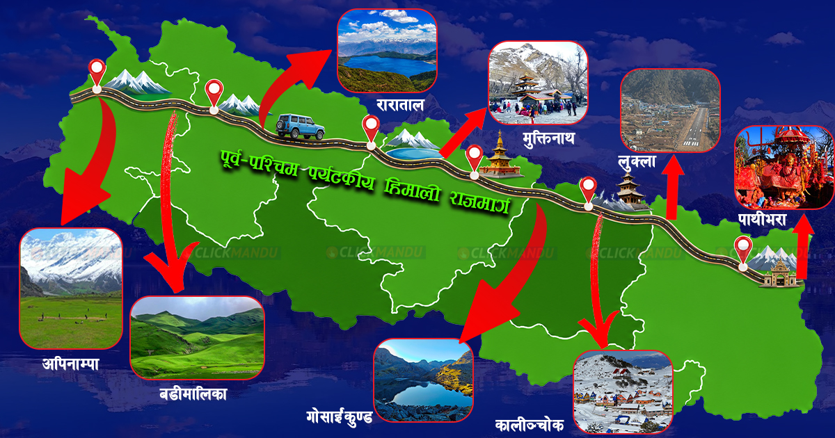
Following his ascension to the premiership, the government has officially incorporated this concept into the upcoming fiscal year’s budget. The Ministry of Infrastructure Development has introduced a strategic plan to conduct feasibility studies for a two-lane road network that will span sixteen Himalayan districts. This network is designed to link various religious and tourist hubs, including Api Nampa in Darchula, Saipal in Bajhang, Rara Lake in Mugu, Muktinath in Mustang, and Lukla in Solukhumbu, eventually reaching Pathibhara in Taplejung. This marks the first time such an integrated Himalayan connectivity concept has moved into the official implementation phase.
The current state of these routes highlights the scale of the challenge ahead. At present, much of the proposed highway consists of rugged dirt tracks or narrow trekking trails, with many sections lacking any road access whatsoever. Ministry spokesperson Ramhari Pokhrel explained that the government has allocated over 41 million rupees specifically for feasibility studies in the coming year to determine how these disconnected segments can be expanded and merged into a cohesive two-lane highway. The goal is to upgrade the existing “one-way” tracks and open new ones where they currently do not exist.
The geographical hurdles are significant, particularly in high-altitude zones. In the Sudurpaschim and Karnali regions, many areas are currently only accessible on foot, requiring days of trekking. The central sections of the route involve crossing world-renowned passes like Thorong La in Manang, which sits at over 5,400 metres. While some areas like Kagbeni to Muktinath already enjoy paved roads, others like the stretches through Langtang and Makalu Barun National Park remain environmentally sensitive and geographically daunting. Infrastructure experts believe that while the project is visionary, its full completion will take years of sustained effort, given the challenging terrain.
In addition to the East-West corridor, the government is also pushing forward with a plan to upgrade six North-South tourist highways into four-lane expressways. The Ministry’s “Red Book” has allocated over 163 million rupees for the study and upgrading of these strategic routes. These projects include major corridors such as the Rani-Kimathanka route in the east, the Birgunj-Rasuwagadhi link in the centre, and the Jamunaha-Hilsa corridor in the west. By expanding these existing roads into four-lane highways, the government hopes to facilitate smoother transit for international tourists and enhance trade connectivity between the southern borders and the northern Himalayan passes.
These North-South projects are categorized into six distinct sections, each receiving dedicated funding for detailed feasibility assessments. For instance, the route connecting Gauriphanta through Attariya to Badimalika is a high priority, alongside the corridor linking Bhairahawa to the Korala pass in Mustang. By focusing on both the East-West Himalayan spine and these North-South arteries, Prime Minister Balen Shah’s administration is laying the groundwork for a massive overhaul of Nepal’s transport and tourism infrastructure, aiming to position the country as a premier global destination for mountain tourism.
Comment Here